See the map below for places to find GOLD in Utah.
What a great OUDOOR adventure!
Listed below are actual locations that I have found gold–not the vague locations of some rumored gold deposits. This map is taken directly from the book:
A Guide to Gold Panning in Utah (Second edition)
If it is on the list, GOLD was found there.
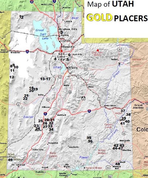
Map Key:
1) Suzanna Canyon; 2) Century Hollow; 3) Willard Canyon; 4) Bingham Canyon; 5) American Fork Canyon; 6) Woodside Gulch; 7) Green River; 8) Lucy L Gulch; 9) Gold Hill Wash; 10) Miner’s Canyon; 11) Clifton/Rodenhouse Wash; 12) Fifteen-Mile Creek; 13) Great Western Hollow; 14) Murphy Gulch; 15) Bates Gulch; 16) Scotia Gulch; 17) East Scotia Canyon; 18) Ibex Canyon; 19) Copperhead Canyon; 20) Copper Canyon; 21) Amasa Valley (and North Canyon); 22) Miller Canyon; 23) Cave Canyon; 24) Lincoln Gulch; 25) Fortuna Canyon; 26) Indian Creek; 27) Sheeprock Canyon; 28) Fish Creek; 29) Little Sevier Creek; 30) Mill Creek; 31) Clear Creek; 32) Revenue Gulch; 33) California Gulch; 34) Pine Creek/Bullion Canyon; 35) Crescent Creek; 36) Straight Creek; 37) Colorado River; 38) Dolores River; 39) Placer Creek (and Miners Basin); 40) Bald Mesa; 41) Wilson Mesa; 42) Johnson Creek; 43) Recapture Creek; 44) Cottonwood Wash; 45) Brushy Basin Wash; 46) Blanding Mesa; 47) Westwater Creek (and 3rd Reservoir); 48) San Juan River; 49) Beaver Dam Wash.
Base map courtesy of Pat online downloadable, portable atlas, 2016. Pat is an online, downloadable, portable atlas that is in the public domain and free to use. http://ian.macky.net/pat/map/us/ut/ut.html. |